
Los Angeles Earthquake: Commerce Quake, Magnitude and USGS Map
What USGS recorded near Commerce on November 20, how to read the Los Angeles shaking maps, and where to check aftershocks and local updates.

Contents8
- What happened in the Los Angeles earthquake near Commerce?
- Why do Los Angeles earthquake reports show different magnitudes?
- Where was the earthquake felt around Los Angeles?
- How do you check the USGS map for this earthquake?
- Does the Commerce earthquake mean a larger quake is coming?
- What should you do if shaking starts again?
- How can you report feeling the Los Angeles earthquake?
- What information is still worth checking after the quake?
The Los Angeles earthquake on November 20, 2026, occurred near Commerce at 3:25 a.m. Pacific Standard Time. The USGS event record retrieved for this report lists a reviewed magnitude of 4.2, a location approximately one kilometer northwest of Commerce, and a depth of about 15.5 kilometers. Those details identify the particular event behind searches for "LA earthquake" and "earthquake Los Angeles," rather than a different tremor elsewhere in California.
People looking up the quake usually need several answers at once: when it happened, where the epicenter was, whether the number they saw earlier has changed, and what the map says about their neighborhood. The event identifier, ci41364111, is the most useful way to keep those answers attached to the same earthquake as the record develops.
What happened in the Los Angeles earthquake near Commerce?
The Los Angeles earthquake near Commerce was recorded at 11:25:35 UTC on November 20, equivalent to 3:25:35 a.m. PST in Southern California. USGS places its epicenter near Commerce, southeast of central Los Angeles, rather than treating the entire metropolitan area as a single point.
Detail | USGS record retrieved for this report | Event identifier |
|---|---|---|
ci41364111 | Magnitude | 4.2, local magnitude |
Location | 1 km northwest of Commerce, California | Local occurrence time |
November 20, 2026, 3:25:35 a.m. PST | Depth | |
Record status | Reviewed at retrieval | Approximately 15.5 km |
The time of an earthquake and the time a webpage was updated are different fields. An update later in the morning does not mean a second magnitude-4.2 earthquake occurred at that update time. Compare the event identifier and origin time before deciding that two notifications describe separate shocks.
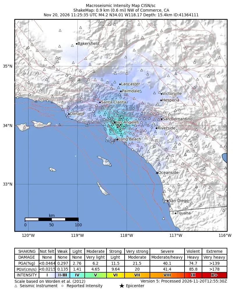
The official USGS ShakeMap below shows the estimated distribution of shaking for this specific earthquake, with its own event information and intensity scale.
Why do Los Angeles earthquake reports show different magnitudes?
Different Los Angeles earthquake magnitudes can appear because early measurements are revised as additional seismic data are processed. For this report, the retrieved USGS record says 4.2; an earlier screenshot or another service may display a different preliminary number.
A useful comparison includes the agency, event identifier, magnitude type, and update time. Comparing only two large numbers in social posts can turn an ordinary revision into an apparent contradiction. The depth and location may also change during analysis, so a report copied early in the sequence can differ in several fields.
A revision is not evidence that the earthquake happened twice or became stronger after it ended. It is a change to the estimated description of the event. If you share an update, attach the latest record rather than recycling an older graphic because it has already received more attention.
Where was the earthquake felt around Los Angeles?
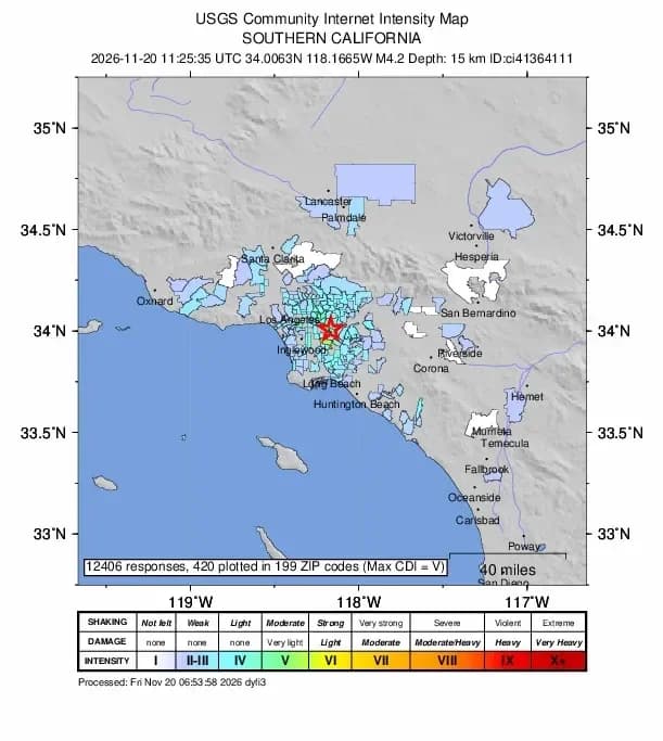
Where the Los Angeles earthquake was felt is best examined through the event's USGS Did You Feel It reports and ShakeMap, which describe different kinds of evidence. The epicenter is a location; the felt area is a broader pattern that depends on distance, ground conditions, buildings, and the people reporting their experience.
Did You Feel It collects observations from the public. ShakeMap estimates the spatial distribution of shaking using instrumental and other information. Neither should be read as a street-by-street structural inspection. Two people close together can describe different experiences, especially if one was asleep upstairs and another was outside.
The community intensity map below belongs to the Commerce event. Its colors concern reported shaking, rather than separate earthquakes at every colored location.
How do you check the USGS map for this earthquake?
To check the USGS map for the Los Angeles earthquake, locate event ci41364111 and confirm its November 20 origin time before opening the associated map products. Our USGS earthquake map guide explains the broader search and filtering process.
Set a time range that includes the early morning of November 20 in California.
Zoom to the Los Angeles area instead of relying on a nationwide list.
Check that the selected event is near Commerce and has the matching identifier.
Compare magnitude, depth, and the record's update time.
Open the shaking or felt-report product that answers your specific question.
If the quake disappears after changing filters, check the minimum magnitude and displayed time range. A restrictive filter can hide an event without any change to its underlying record. Also remember that UTC dates and California dates can differ near midnight.
Does the Commerce earthquake mean a larger quake is coming?
The Commerce earthquake does not establish that a larger earthquake will occur at a particular time. USGS distinguishes probabilistic forecasts from exact predictions, and scientists cannot reliably specify the date, location, and magnitude of a future major earthquake.
Aftershocks are possible after an earthquake, but a possible aftershock sequence is not a schedule. A viral message giving an exact hour for a larger quake should not be treated as an official forecast. The same applies to claims based solely on unusual weather, animal behavior, or a pattern drawn through unrelated earthquake dots.
A practical response is to check current official information and your surroundings, rather than repeatedly refreshing an alarming countdown. Regional preparedness remains useful whether the next hours are quiet or contain additional small events.
What should you do if shaking starts again?
If shaking starts again, standard earthquake guidance is to drop, cover, and hold on when you are indoors, while protecting your head and neck. Stay away from windows and objects that could fall; do not rush through a building while the shaking is continuing.
After shaking stops, check for injuries and immediate hazards around you.
Use stairs rather than an elevator if you must leave a building.
Follow building staff and local emergency instructions where damage or a hazard is suspected.
Keep shoes and a light available when broken glass or a power interruption is possible.
Use emergency services for urgent danger rather than for general magnitude information.
An online shaking map cannot tell you whether a particular apartment, school, or workplace is safe to enter. A building-specific decision requires the relevant local authorities or qualified inspection, especially if visible damage, a gas smell, or an electrical hazard is present.
How can you report feeling the Los Angeles earthquake?
You can report feeling the Los Angeles earthquake through the Did You Feel It questionnaire attached to the correct USGS event. Describe your own location and observations, rather than copying what a nearby person reported or estimating what must have happened across the city.
A useful account distinguishes movement you felt from damage you actually observed. Public responses help characterize shaking, but a growing response count is not a count of injuries, damaged buildings, or all people exposed. The total also changes as more people wake up and submit their experiences.
What information is still worth checking after the quake?
After the Los Angeles earthquake, the most useful follow-up information is the current USGS event record together with local notices about specific damage, transport, utilities, or building access. Scientific measurements and municipal operational updates answer different questions.
Before acting on a dramatic claim, check whether it names a location, gives a current timestamp, and comes from the organization responsible for that issue. A nearby earthquake record alone does not confirm a freeway closure, an injury total, or a utility outage. Keeping those distinctions clear makes the next update easier to assess and reduces the risk of sharing an old incident as today's news.
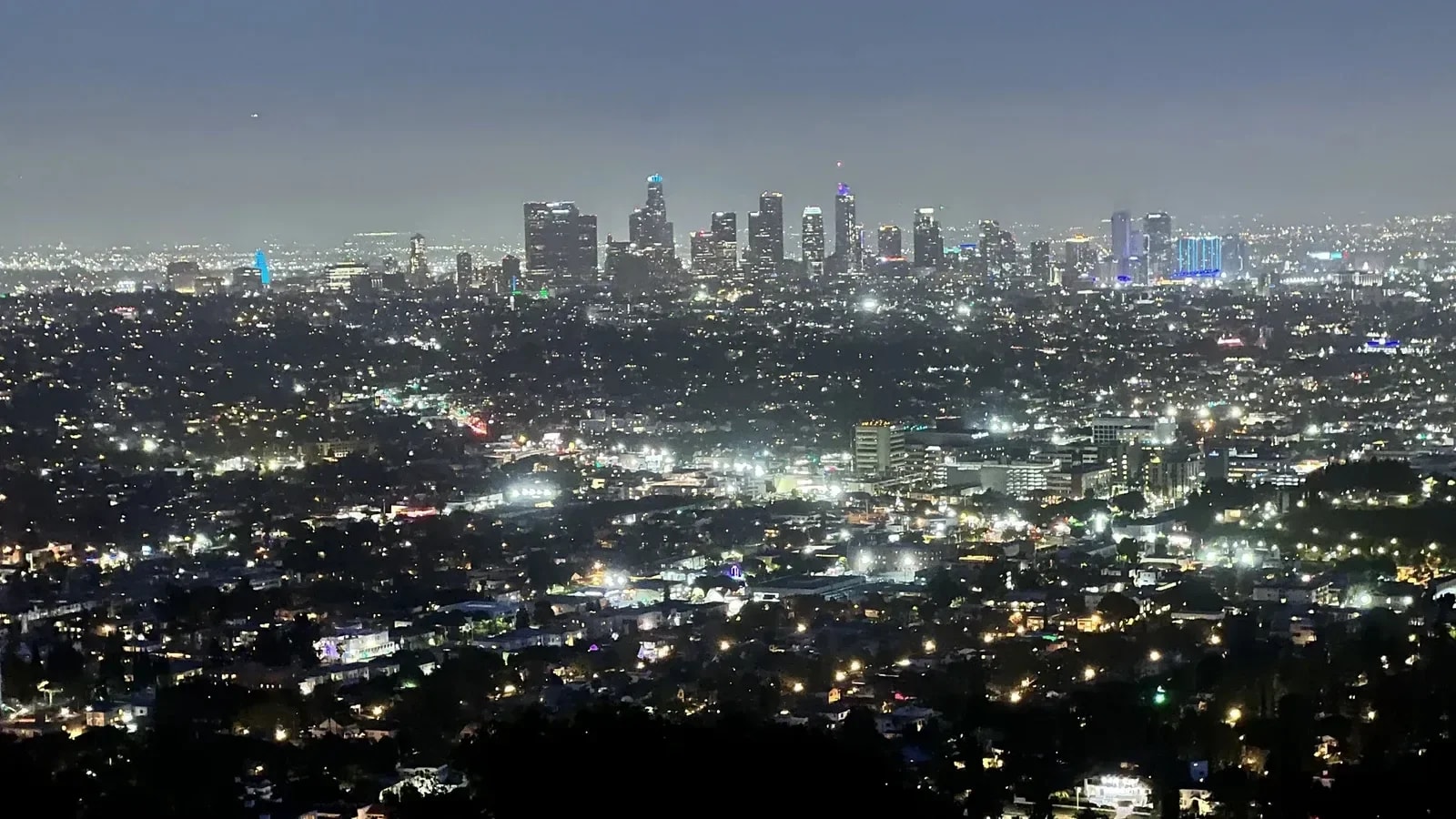
The cover shows Los Angeles at night in an archival NASA photograph by J. Jeletic, taken May 8, 2022. The event maps inside this article show the November 20, 2026 Commerce earthquake.
Best of the week — in your inbox
No spam. Only top Gosta stories. Unsubscribe in one click.
Comments